Santa Ana River Basin - Riverside Levees Rehabilitation Project
Project Description
This U.S. Army Corps of Engineers (USACE) led Santa Ana River Basin- Riverside Levees Rehabilitation Project will rehabilitate damaged portions of the Federally constructed Riverside Levee 1 (West levee) and Riverside Levee 2 (East levee), collectively the "Riverside Levees," which are part of the Santa Ana River levee system. Approximately 9,000 feet of the West levee will be rehabilitated starting from Market Street and continue southwesterly downstream to just past Capary Road. Approximately 4,000 feet of the East levee will be rehabilitated starting from the County line and continue southwesterly downstream to approximately Columbia Avenue. This project also includes a short reach of the East levee between Market Street and State Route 60. Levee rehabilitation will include replacing and grouting the existing levee rock slope protection, as well as extending the rock slope protection (see Exhibits 1 & 2 below)
Exhibit 1 – Riverside Levees Exhibit
![]()
Project Purpose, Need and Benefits
The purpose of the Santa Ana River levee system is to reduce the potential for Santa Ana River flows to break out of the channel and flood adjacent properties. The levees range from 15 ft. to 22 ft. in height above the elevation of the riverbed. The levees were originally designed in the 1950’s to convey a flow of approximately 195,000 cubic ft. per second (cfs), well in excess of the estimated 100- year flow of 140,000 cfs.
A series of storms from December 2010 to January 2011 resulted in substantial flows in the Santa Ana River and damaged portions of the Santa Ana River levee system. Inspections performed by the Riverside County Flood Control and Water Conservation District and USACE in June 2011 identified damages to the Riverside Levees, including intermittent erosion at the toe of the riverward slope and the erosion of several groins on both banks of the river. Most of the damage was to the groins, which act as rock brake pads to slow the flow of water near the levee.
The rehabilitation of Riverside Levees is authorized by Public Law 84-99. Public Law 84-99 authorizes USACE to assist local governments with the rehabilitation of Federal and non-Federal flood risk management projects damaged by flooding.
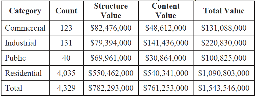
The Riverside Levees rehabilitation project will not only restore but enhance the levees to ensure they continue to protect approximately $1.5 billion of infrastructure. The project will ensure flood protection for more than 4,300 structures, of which more than 4,000 are residential structures in the Riverside and Jurupa Valley areas. A summary of the structures being protected by Santa Ana River levee system is provided in Table 1 and Figure 1 below. In addition to protecting property, the rehabilitation project will provide additional scour protection and integrity to the Riverside Levees.
Figure 1: Location of Structures being protected by the Riverside Levees Project
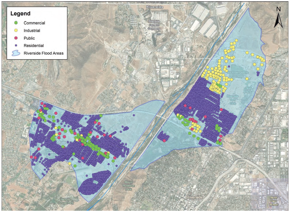
Table 1: Summary of Structures protected by the Riverside Levees Project

Santa Ana River Trail Detour Information
As construction on the Riverside Levees Rehabilitation Project continues along the Santa Ana River, sections of the Santa Ana River Trail are now temporarily closed to ensure public safety.
A staging area and temporary equipment ramp have been placed just northeast of Riverside Avenue to support construction activities. Flaggers are directing traffic in this area to ensure safe conditions for both workers and the public. Flaggers will be at this location throughout project construction.
Trail users can expect temporary detours now in the following areas:
- Detour 1: (OPEN NOW until July 2026): Riverside Avenue/Main Street to Columbia Avenue
- Detour 2: (OPEN NOW until July 2026): Market Street Bridge to CA HWY 60
Each detour is clearly marked with signage and alternate route information. Detours will be removed, and the bike trail will reopen as soon as work in each area is complete.
For questions regarding the Riverside Levees Project, contact Kelly O'Sullivan at 951-955-4643.
Project Status and Outreach to Those Experiencing Homelessness Within the Santa Ana River Construction Area
The levee rehabilitation project is scheduled to restart construction in April 2025. Construction is estimated to take four years.
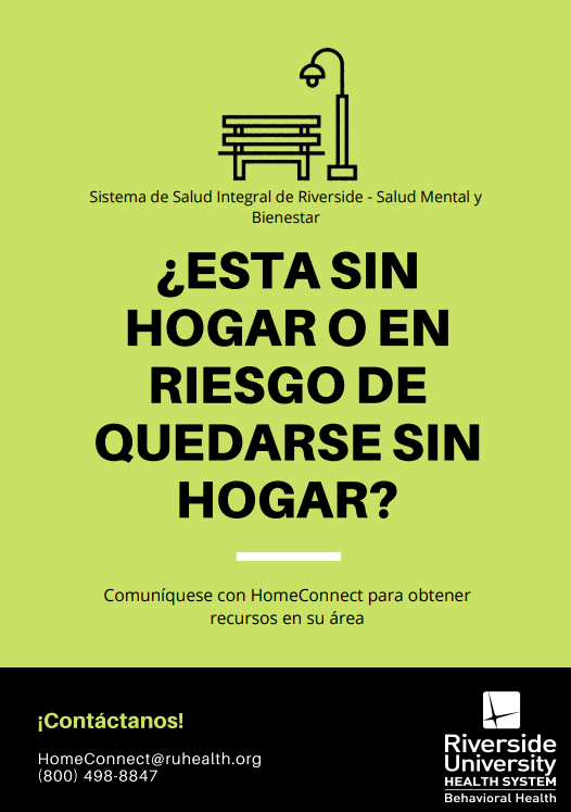
To protect the safety of those that are experiencing homelessness in the river bottom, the Riverside County Flood Control and Water Conservation District began a partnership with local city, county and non-profit outreach teams and service providers in September of 2021 to educate those dwelling in the river about the pending project and to offer services including housing alternatives ahead of construction. For the past year staff from multiple agencies have been communicating the importance and timeline of the project, partnering to identify safe shelter, and providing options for storing belongings. Additionally, as the project progresses, the Riverside County Flood Control and Water Conservation District and its partners will continue to reach out to impacted area inhabitants to provide education, support services and information on when they should plan to move to keep them safe from the construction activities and allow time to find alternative accommodations as the project progresses along the river.
Resources
If you need shelter, please contact:
Path of Life Ministries Family Shelter
(951) 462-9822; [email protected]
or
Riverside County HomeConnect
(800) 498-8847; [email protected]
For Health and Social Services Referrals Call: 2-1-1