
Pre-District Years
Western Riverside County was viewed by its early pioneers as a land of great opportunity. But history reveals that there were shortcomings in this "land flowing with milk and honey". Devastating floods that took lives and destroyed property, had their way, virtually uncurbed, during the first half of this century. In the days of the early settlement of the County the pioneers suffered damage to their property and took the loss as a part of pioneering.
But as the County prospered and property became more developed and roads and bridges were constructed, the damages from flooding increased. Citizens began to form coalitions to fight back against the forces of nature.
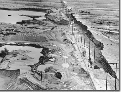
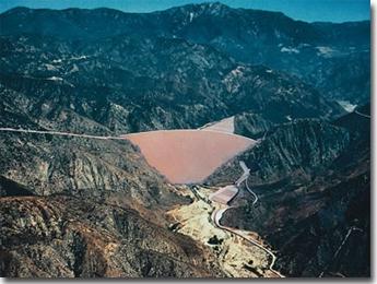
Image
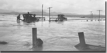
San Jacinto River flood waters inundated Perris, California in the devastating 1927 flood.
In 1908, fifteen years after the creation of the County, citizens in the San Jacinto Valley formed the San Jacinto Levee District, with property owners assessing themselves to build and maintain a protective levee along the San Jacinto River with aid from the County, State and Federal governments. Others followed San Jacinto's lead. Citizens in the Coachella Valley formed the Coachella Valley Storm Water District in 1915, and the Valle Vista Levee District was formed in 1932 to control flooding along Bautista Creek east of Hemet. San Bernardino County, through action of the State Legislature, created its flood control district in 1939.
The devastating floods in 1938 made it painfully clear that Riverside County government did not have an adequate program of flood protection. In June of 1944, as war continued to be waged in Europe and the South Pacific, the Riverside County Board of Supervisors decided to wage a war against flooding. What delayed action on this front between 1938 and 1944 is not clear. Perhaps it was the preoccupation with the war itself. San Bernardino County, with the creation of its flood control district in 1939 provided a blueprint that served as a guide for our County. The process in Riverside County began in June 1944 with each Supervisor appointing three representatives to what became known as "the Committee of 15". They were tasked with deciding how to best approach this local war on flooding.
Later in 1944 at one of their meetings, A. C. Fulmor, the County Surveyor, presented a comprehensive and visionary report. In that report he made the following observations:
- As a general law county "The power of the Board of Supervisors to do work of this kind (flood control) is pitifully inadequate."
- The County focus is on protecting roads and public property, not private property.
- Water conservation is an absolute necessity.
- The Federal Flood Control Act of 1938 provides funding through the Corps of Engineers (COE) that the County should pursue. The COE, however, finds it difficult to work with those counties not having a flood control district.
- A flood control district will provide the opportunity to collect data and guide future planning.
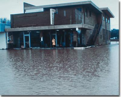
Image
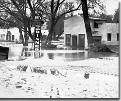
In March 1938 the Santa Ana River overtopped its banks and flooded a portion of northwest Riverside. Note the high water mark on the trees.
Riverside County weathered many significant storms in its formative years, but it received a wake-up call in March 1938. It was a call that could not be ignored. Storms of the past had been limited in their areas of impact and losses had been primarily to agricultural lands and to roads and bridges. Losses were measured in the tens of thousands of dollars. However, 1938 was different, very different. Nearly all bridges across the Santa Ana River were swept away, including the Pedley (Van Buren) Bridge, Riverside, and the Norco Bridge.
The City of Riverside was particularly hard hit by the uncontrolled Santa Ana River, forcing people from their homes in the northern sector of the city. Quoting from a report of the Advisory Committee on Flood Control filed later that year:
"Many persons were forced from their homes, or were isolated in them as the perilous situation developed so suddenly that but brief warning could be given. A number of men, women and children were rescued from trees where they clung when unable to reach higher ground after leaving their imperiled homes. . . .City in darkness. Riverside was without light or power from 5:15 p.m. on March 2nd to 3:00 a.m. on March 3rd. Hospitals, theatres, stores and homes were crippled in their operation. Most of the places of business were closed except night cafes where flickering candles were in use."
The desert was similarly devastated by the raging Whitewater River. Tourists were unable to leave Palm Springs for almost a week. There were a number of fatalities throughout the County and damages approached a staggering $2 million. To put that cost in perspective, the average cost of a five-room house in 1938 was $3000.00.
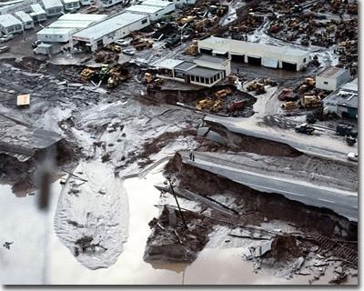
Image
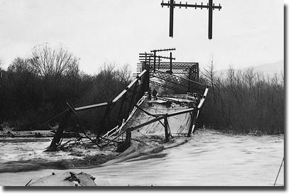
An old steel bridge over the Santa Ana River which collapsed during high flood flows on January 19, 1916.
Formative Years
Mr. Bookman emphasized the District's water conservation responsibilities. He instituted a groundwater level monitoring program and took over the San Jacinto River Spreading Grounds from Fruitvale Mutual Water Company. Whereas groundwater recharge at this site had been quite informal, the District improved the facility to enhance recharge and to measure quantities spread.
Mr. Bookman also began a data gathering system of rain and stream flow gagging stations, and started bank erosion control using apricot tree cuttings placed between wire fences along the San Jacinto River.
Mr. Bookman left the District in September 1950 to join the State Division of Water Resources. He is remembered for establishing the District as the primary basic hydrologic data collector in western Riverside County. Mr. Wayne Lill, Associate Civil Engineer, was appointed Acting Chief Engineer and in 1951 was succeeded by Mr. N.B. Smith as Chief Engineer.
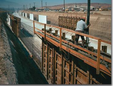
Image
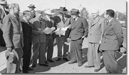
Standing on the Mission Boulevard Bridge reviewing project plans for the Santa Ana River Levees, Riverside, are representatives of the State Water Resources Control Board, U.S. Army Corps of Engineers and Metropolitan Water District and State Engineer Hyatt, County Supervisor Pittman and (far right), the District's first Chief Engineer, Max Bookman.
Image
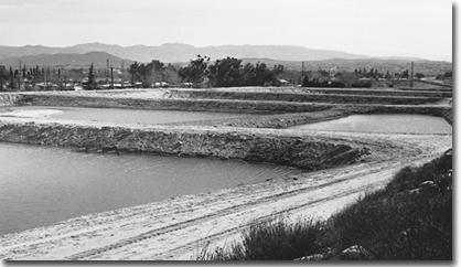
Little San Gorgonio Creek spreading grounds, typical of several facilities operated by the District. Minor storm flows are turned out of the main stream into basins where the water percolates to groundwater. This facility is still in use conserving floodwaters.
Coming of Age Years
1953
Mr. John Bryant was recruited as the District's Chief Engineer from the Region 6, Bureau of Reclamation office in Billings, Montana in July 1953. His first priority was to construct a series of six earth fill dams in the hills south of the city of Riverside to control hazardous flood waters emanating there from. Harrison and Woodcrest Dams were completed in 1953, and all six were in place by 1960. In addition, Pigeon Pass Dam above Sunnymead was completed in 1957.
1955
In 1955, Ordinance 460 made the District responsible for ruling on the level of flood protection to be provided on new subdivisions. Riverside County became the first in the state to require 100-year flood protection on new land divisions. Since then 100-year protection has become standard throughout the state and the nation and was also adopted in the National Flood Insurance Act of 1968. Therefore, in 1955, to facilitate its responsibilities under Ordinance 460, the District embarked upon an ambitious program of mapping its entire area at a scale of 1" = 200' with 4' contours, by using the new technology known as Photogrammetry. Ground control surveys and mapping was initially done by a private photogrammetric contractor providing maps covering one square mile each.
1956
The Santa Ana River levees through the city of Riverside became the first Federally funded District project in 1956. The levees were designed to protect the city from severe flood damage similar to that experienced in the flood of 1938. The project increased the budget from $890,000 in 1955-56, to $3,440,000 for 1956-57. The salary item in the 1956-57 budget was $78,000 for a staff of 14, including a Chief Engineer, four Civil Engineers, one Hydrographer, one Right of Way Agent and one Draftsman.
1957
By 1957, staff growth prompted a move from the courthouse to 2,300 square feet of rental space in the Schacker Building, a block away at 9th and Orange Streets. Also in 1957, the District became the first public agency to set up an in-house division of photogrammetry to produce maps using aerial photography. The average cost for contracted work had been $1,000 per square mile (per map) excluding ground control. The new division was able to produce one square mile of mapping, including ground control, for $355.
1960
The State Division of Highways, in constructing Highway 60 through Riverside, severed about 15 acres off the north end of Fairmount Park golf course which became surplus property. The District purchased the parcel, bounded by Highway 60, Market Street and the Santa Ana River levee, for a modest $28,000. Armed with this choice land parcel, the District proceeded to design, and put out to contract, a 10,500 square foot office building at its present location. Thus the District was to have the first home of its own.
1961
District workloads increased substantially between 1957 and 1961, requiring a staff increase from 14 in 1957 to 55 in 1961, and the newly completed office building was occupied in February 1961.
1962
Completed in 1962, the San Jacinto River levee project was designed and constructed with Corps of Engineers funds and consisted of five miles of levee along Bautista Creek and the San Jacinto River in Zone 4. The District provided funds for right of way, utility relocations and bridges. These local costs were reimbursed to the District by the state.
The District began using electronic distance measuring (EDM) devices in 1962, significantly speeding up survey distance measuring. An EDM could accurately measure one mile or 20 miles in just minutes. With conventional transit and steel tape, a like survey line would take hours, and if the line of sight needed clearing of brush and trees, it could take days.
1963
The District maintenance force was originally headquartered on County Road Department property in San Jacinto and much of its work in the early years was along the San Jacinto River in Zone 4. In 1963, a 50' x 100' concrete "tilt-up" building was erected at District headquarters in Riverside and the maintenance function moved there.
On October 18, 1963, Orange County Water District filed a lawsuit against virtually all Santa Ana River Basin water users upstream of Prado Dam, except the San Jacinto River Basin tributary to Lake Elsinore.
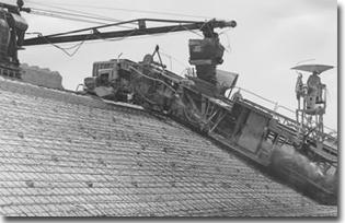
Image
Kelsh Plotter - Initial machine used to launch the District's "in-house" photogrammetric mapping program in 1957.
Image
Pigeon Pass Dam above Moreno Valley was completed in December 1957 and continues to protect this now highly developed area.
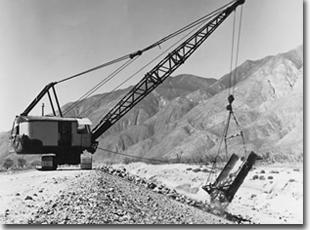
Image
Slope Paving on Bautista Creek, June 1961.
Exercising its authority and water conservation responsibilities, the District provided legal and engineering representation for more than 200 public and private water users within its boundaries. Also, the District established and supervised the "water defense office" in Riverside. It was the distribution center and repository for water suit data on behalf of all upper Santa Ana River basin defendants.
Four and a half years later, in February 1968, upper basin interests filed a cross complaint against Orange County water users, and on April 17, 1969, the suit was settled by "physical solution" providing for an annual minimum Santa Ana River flow through Prado Dam in terms of quantity and quality.
The Water Defense Office closed on June 30, 1969, with 4,149 parties, defendant and cross defendant, having been named and served. Thus was concluded the most massive lawsuit in California water history, with the District having played a significant role in defense of its area water interests.
1964
Historically, all calculations for surveys, design, hydrology, etc., were performed using slide rules and mechanical calculators such as the "Frieden". These calculations are quite labor intensive, slow and tedious. Some design problems require multiple trial computations to arrive at the optimum engineering solution. Hydrologic and survey computations likewise are complex and require inordinate amounts of time to complete.
Faced with increasing workloads, the District purchased its first full fledged computer, an IBM 1620, in November, 1964. It had 20,000 bytes of mass storage. All major calculations in engineering and surveying were quickly shifted to the new machine. A water surface profile calculation which previously took about one week to complete, could now be done in less than a day. Two years later, the District bought its second digital computer, trading in the 1620 on an IBM 1130. The 1130 was faster and had more storage (100,000 bytes of mass storage) and cost less. Extensive engineering software was developed by District staff to do hydraulic, hydrologic and structural computations utilizing the 1130.
During the March 1938 flood event, major flooding from Tahchevah Creek occurred through downtown Palm Springs. In 1964, Tahchevah Dam was constructed to control flood waters originating from the steep mountainous watershed above the city (see picture, left). The project, built by the Corps of Engineers, at a cost of $1.2 million, was partially funded by the District and the State, and is maintained by the District.
Image
Placing rock revetment on the San Jacinto River Levee during its construction by the Corps of Engineers in 1961.
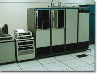
Image
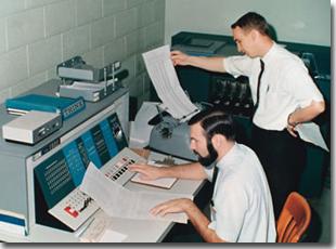
The District's first computer, an IBM 1620, was put into use in 1964.
1965
In November of 1965, Southern California experienced the most significant rainfall flooding since 1938. The first storm occurred from November 13 - 19, followed by another storm November 21 - 26. Because of the ground saturation from the earlier storm, the second storm caused significant runoff in streams in Riverside County and especially in the desert areas of the district.
Cottonwood Creek overflowed Interstate 10 east of Highway 111 junction and all traffic was stopped for several hours. The lack of all-weather bridges and flooding of major roads resulted in the cities of Desert Hot Springs and Palm Springs being isolated for a period of time. Access to other communities in the Coachella Valley was severely impaired. Several lives were lost as a result of people trying to drive across streams at "dry"-weather crossings. Cars were swept away, some with passengers trapped inside. Most District facilities were put to their first real test. For the most part, they performed well. The floods of 1965 did demonstrate the need for major flood control improvements throughout the district.
1967
By 1957, the topographic (contour) maps, produced by photogrammetry, were in such demand by private engineers involved in new land development that it was necessary to expand the division to keep up with the demand. In addition, the District's planning, design and subdivision processing requirements for topographic maps were increasing, and other County departments likewise were making increased use of District topographic maps.
Initially recommended by the U. S. Public Health Service in 1951 and subsequently by the Santa Ana Regional Water Pollution Control Board and the State Department of Water Resources, the non-reclaimable industrial wastewater line from the upper Santa Ana Basin area to the Pacific Ocean was investigated, planned and preliminarily designed by the District in the late 1960's. The pipeline carries away saline mineral wastewaters which would otherwise diminish groundwater quality. Though ultimately built by other agencies, the project is essentially as envisioned and planned by the District and has facilitated significant industrial development upstream from Prado Dam.
1968
Wide Canyon Dam, east of Desert Hot Springs, was constructed to control flood flows from a large drainage area prone to producing flash floods. At the time of its construction in 1968, it was the largest of the nine flood control dams built by the District.
1969
Two storm periods in January and February of 1969 produced flood peaks in the Santa Ana River at Riverside greater than any in the previous 31 years.
The 10-day storm period, January 19-29, produced more than 7 inches of rainfall in Riverside. This was noteworthy as the annual average rainfall for the previous 89 years was eleven inches. Storm total precipitation at Lake Arrowhead was 42 inches, with 29 inches in the form of rain.
Image
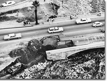
November 1965 flood. Highway 111 in Palm Springs was cut in two places disrupting traffic for several days.
Image
Whitewater River at Indian Avenue as it appeared on March 23, 1965. Indian Avenue was destroyed by flood waters cutting back from a sand and gravel pit on the downstream side. The closing of Indian Avenue for 30 days added to the isolation of Palm Springs.
The resulting peak flow at Riverside Narrows was 41,000 cubic feet per second on January 25th. Prado Dam experienced a peak in-flow of 77,000 cfs on January 29th. Above normal rainfall occurred throughout western Riverside County causing significant flood damage. The northbound lane fill section of Van Buren Boulevard Bridge over the Santa Ana River washed out on January 28th. The Mira Loma area and the Temescal Creek area in Corona each suffered some $2,000,000 (in 1969 dollars) in damages. Included were complete severance of East 6th Street and the washout of 1,300 feet of Pacific Electric railway track in Corona.
The President of the United States declared Riverside County, along with 35 other California counties, a disaster area on January 26th.
The six District dams around the south and east sides of Riverside stored the greatest amount of flood waters since their construction and City of Riverside flood damage was reduced by virtue of the storm volume controlled by the dams. Other District facilities - dams, levees, storm drains and channels generally performed well and prevented much potential damage.
Following nearly 9 inches of January rainfall in Riverside, and some $15,000,000 in flood damage in the County, repair work proceeded in most areas. The Van Buren Boulevard fill section was restored to traffic use by mid-February, as was the East 6th Street crossing of Temescal Creek in Corona. Between February 5th and 23rd, the Santa Ana watershed soils, still draining January storm moisture, received yet another 3.6 inches of rainfall at Riverside and more than 25 inches at Big Bear Lake, typical of the upstream, higher elevation areas. Then 5.72 inches fell in Riverside February 24th through 26th, bringing the rainfall total at Riverside, for January and February, to 18.19 inches.
February storm flows caused much more damage than those of January. Antecedent (January) rainfall had rendered watersheds saturated and surface materials loose. This scenario encouraged damaging flows for longer periods and resulted in increased debris volumes.
Both southerly concrete spans of the Van Buren Boulevard bridge over the Santa Ana River collapsed. The river also washed out part of the River Road (Auburndale) bridge downstream. Temescal Creek again severed East Sixth Street, Corona, as well as Hamner Avenue and River Road near Hamner. Other flood damage areas included Oak Street Channel, Corona; San Jacinto River, Lakeview; Salt Creek at Goetz Road; Little San Gorgonio Creek at the spreading basins, Vineland Street and Cherry Valley Boulevard; Noble Creek at Cherry Valley Boulevard, Beaumont Avenue and 14th Street; San Gorgonio River at South Cabazon; Tahquitz Creek at Sunrise Way, Palm Springs; and Murrieta Creek, Temecula.
The January-February 1969 storms resulted in $40,000,00 (1969 dollars) in damage to public and private property in Riverside County. The County suffered greater damage than 32 of the 35 "disaster" counties in California.
1970
The citizens of Zone One, having been dramatically awakened to the power of flood waters during the 1969 storms, approved by a strong majority, a $30,000,000 bond issue for flood control improvements in November 1970. The bond issue was the first in District history.
1971
Armed with the bond funds and higher tax revenues, the District forged ahead with design of major Zone One projects. Combined bond monies and pay-as-you-go funding was projected to be $38,000,000 for a 15-year program. In order to expedite the design work, staff increased to 100 and was supplemented by contracting with private engineering firms for additional design capability. As a result, early construction of several large projects was accomplished and considerable cost saving was achieved through avoidance of higher than anticipated inflation rates in the later years of the program.
The substantial increase in engineering design load required additional office space, and that was achieved through a 5,500 square foot addition, plus some interior remodeling to better utilize existing space.
Image
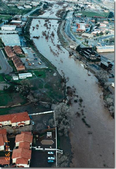
Flooding of the Brockton Arcade area of Riverside in February 1969.
Image
Aftermath of the storm of February 1969 flooding on Temescal Creek in Corona, Magnolia Avenue and the Pacific Electric Railroad tracks. This problem was corrected by the construction of Temescal Creek Channel.
1974
By 1974, District staff grew to 110, and the combination of bond funds in Zone One and increased tax rates in all zones pushed the budget to an all time high of $28,550,000.
Computing capability was enhanced with the 1130 computer system being replaced by a Hewlett Packard Model 3000 computer. Having 320,000 bytes of memory storage and capable of handling 16 users, simultaneously at separate work stations, this system with periodic upgrades, became the mainstay of the District's all around engineering computational tools.
Purchase of an orthophoto stereo plotter in 1974, enabled the District to become first in the nation, and the world, to produce a digital topographic map in a production environment. Now it was possible to produce a three-dimensional drawing, by computer, to show how a proposed project would look upon completion.
The benefit of District computer utilization is demonstrated by the estimated 100 man years of engineering time saved, a total worth of approximately $2 million, during the short period 1973 through 1977.
Image
The HP3000 system with its periodic upgrades stood the test of time. For 16 years all the District's engineering, surveying, accounting and maintenance scheduling computing was performed using the HP3000. Currently, most of the engineering and surveying computing has migrated to personal computers.
1975
The District, since its inception in 1946, was a principal collector of basic hydrologic data. In the early 1960's it was using automatic devices to continuously record rainfall and stream flow at specific sites. However, in July 1975 a telemetered flood warning system was begun. Thirteen remote stream flow gages utilized radio equipment (some solar powered) to report storm flow events to District headquarters. In addition, flow recorders began to be used in improved District flood control channels.
1976
Acquisition of a flatbed graphics plotter in 1976 completed the District's automated mapping process, completely eliminating hand-drawn ground contours, a tedious and expensive activity. Visitors from Europe, U.S. Geological Survey, CIA, Caltrans, State Department of Water Resources, and others came to view the automated mapping process. The District's photogrammetrist was called upon to give system presentations in Washington, D.C., Little Rock, San Francisco, New York and Ottawa, Canada.
1977
The total expended for District constructed projects through 1977 was $42,000,000, with Zone One Bond issue projects being 70% completed in only 40% of the programmed construction period. Therefore, major flood protection facilities were in place sooner than anticipated and at a savings in cost due to the reduced impact of inflation. Two of these major projects in Riverside were Arlington Channel Stage 1 and Magnolia Center Storm Drain Stages 2 and 3.
Image
Arlington Channel was a major construction project for the District. It was in the planning stages for many years until construction funds became available through the passage of the 1970 bond issue. With its completion, development in southwest Riverside was able to proceed.
Growth Years
1978
In the Spring of 1978, John W. Bryant retired after serving 25 years as District Chief Engineer. During his tenure, staff grew from 14 to 110, and design and construction was completed on 9 dams and countless miles of channels, levees and underground storm drains. The first District office building, on District owned land, was constructed. The non-reclaimable industrial waste line to the Pacific Ocean was envisioned, planned and preliminarily designed. His appearances before Congressional committees in Washington resulted in receipt of nearly $13 million in Federal funds to assist in financing projects within the District.
Later in 1978, Assistant Chief Engineer, Kenneth L. Edwards, was appointed Chief Engineer. He had joined the District in January 1962 as its Planning Engineer, coming from the Los Angeles District office of Corps of Engineers.
In June 1978, the voters of the State of California approved Proposition 13, which amended the State Constitution to, in part, limit the maximum ad valorem property tax to one percent of the value of real property, and future bonded indebtedness was severely limited. The passage of Proposition 13 had an immediate impact upon local government financing. By virtue of the formula distributing the one percent property tax collected, the District suffered a 60 percent reduction in projected property tax revenue for Fiscal Year 1978-79.
At the same time, Riverside County and the District experienced a most phenomenal growth period beginning in 1978. Such fast growth, coupled with the revenue limitation, placed a significant strain on the District to provide adequate service to the public. In order to cope with the demands of growth the County, urged by the District, levied fees on new development for flood control and drainage purposes.
The storms of February/March 1978 caused extensive damage throughout the District. Flood damage occurred at Wildomar, Winchester, Corona, Murrieta, Cherry Valley, Lakeview-Nuevo, Calimesa, San Jacinto-Hemet, Palm Springs and Desert Hot Springs. The Oak Street Channel in Corona experienced flooding similarly to 1969. Also in February 1978, the District's Woodcrest Dam, south of Riverside, filled and overflowed the emergency spillway. The overflow was relatively small and caused no damage, but the reservoir spilling was the first and only such event to occur at a District dam to date. Alessandro Dam, southeast of Riverside, filled but did not spill in 1969. Total flood damages in 1978 exceeded $9 million.
Image
Woodcrest Dam Spillway. In February 1978 the dam filled to capacity, overflowing the emergency spillway, the only such event to occur to any District dam to date.
Image
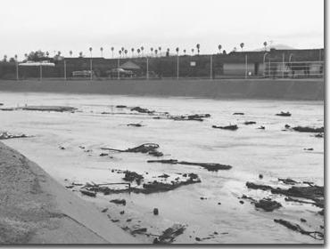
Flooding in the vicinity of State Street (Highway 74) and Ramona Expressway, February 21, 1980, as a result of the breach of the San Jacinto River Levee.
The flows undermined the concrete face toe protection and floodwaters briefly breached the levee on February 21, 1980, but rapid District response with heavy equipment closed the breach and contained the flood flows within the stream. The Smoke Tree Estates development and other commercial and residential properties along East Palm Canyon Drive, were protected from potential catastrophic damages.
The flows undermined the concrete face toe protection and floodwaters briefly breached the levee on February 21, 1980, but rapid District response with heavy equipment closed the breach and contained the flood flows within the stream. The Smoke Tree Estates development and other commercial and residential properties along East Palm Canyon Drive, were protected from potential catastrophic damages.
Also on February 21, 1980, a section of the San Jacinto River Levee immediately downstream of the junction with Bautista Creek Channel collapsed. An estimated flow of 25,000 cubic feet per second had undermined the rock toe revetment and coursed its way through a mobile home park and portions of the City of San Jacinto, with floodwaters several feet deep and causing extensive damage. Other than these two levee failures, the District's facilities performed well and prevented millions of dollars in damages. The City of Riverside saw none of the damages and flooding experienced in 1969, due to protection the completed 1970 bond issue projects and other projects had provided. However, the floods of 1980 also demonstrated a need for additional flood control and drainage improvements throughout the District, where the widespread flooding in western Riverside county accounted for at least ten deaths, and in excess of $70 million in property damage.
1982
Because of the reduced funding from property taxes brought on by Proposition 13 the District placed an issue on the November 1982 ballot for the voters to consider a flood control benefit assessment to fund critically needed projects in all of the zones. Only the voters in Zone 6 approved the assessment which would generate annual revenues for construction of new facilities and would sunset after 15 years. Over the period an additional 25 million dollars would be raised which, when added to available tax revenues, would provide for significant flood control project improvements in the Palm Springs, Cathedral City and Desert Hot Springs areas.
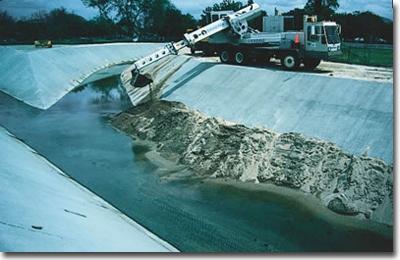
Retention basins are designed to take the "peak" off flood flows, as opposed to dams which can store the design flood for later release. Such basins are dry most of the time and, therefore, may be put to other uses between storms.
Constructed in 1982, the Monroe Retention Basin, better known locally as Don Derr Park, is used by the citizens of Riverside as they enjoy the soccer and baseball fields on the basin's floor. Restrooms and electrical equipment are on high ground while backstops and bleachers, designed to "get wet" occasionally, occupy basin bottom sites. A similar well used facility, the Anza Retention Basin ( Don Lorenzi Park), is also located in Riverside.
Image
The Oak Street Channel Debris Basin was put to its first test in February 1980. The dam and basin were constructed in 1979.
Image
Monroe Flood Retention Basin (Don Derr Park), Riverside. Built in 1982, it is one of several such joint-use District basins. Dry most of the time, basins such as this provide excellent sports and recreation facilities.
1983
The booming development growth during the 1980's required substantial staff increases. As a result, mobile office units were moved onsite to provide additional work space in 1983.
1984
In 1984 the District initiated a sophisticated flood warning system known as Automated Local Evaluation In Real Time (ALERT). It consisted of fifteen rain and stream gages on the San Jacinto River and Murrieta Creek watersheds, which reported the occurrence of rain or stream flow to the Hydrology Storm Center at the office. This enabled rapid response by District staff to unusual storm events.
The digital process continued to facilitate engineering computer programming and mapping. In 1984, the first analytical stereo plotter was acquired. Driven by a computer and storing mapping data in digital form it allowed subsequent drawing on a graphics plotter. Fast and highly accurate, it changed District mapping for the better.
1985
In 1985, the Army Corps of Engineers completed a Reconnaissance Study of a project to improve the Lake Elsinore Outlet Channel. The project would reduce lake flooding levels such as occurred in 1980 and eliminate flooding along the outlet channel from the Lake to Temescal Wash near Riverside Drive. It was estimated that the non-Federal share of the project costs would be in excess of 4 million dollars of which the State would reimburse 70 percent.
1986
The District staff proposed to the Board of Supervisors a plan for eleven critically needed projects around Lake Elsinore including the outlet channel. A plan to issue 8 million dollars in bonds secured by a benefit assessment on all properties draining into the lake and benefitting from the projects was proposed. Supplemental funding from tax revenues was also a part of the plan. The Board of Supervisors and the Lake Elsinore City Council approved the plan and the issue was placed before the Zone 3 voters in November 1986, and a strong majority approved the assessment and the issuance of the bonds. Two years later, the Army Corps of Engineers completed a Detailed Project Report for the Lake Elsinore Outlet Channel and Corps Headquarters in Washington, D.C. approved the project and provided funding to commence construction plans.
Also in 1986 Congress authorized $1.4 billion for the Santa Ana River Mainstem Project, which provided for the construction of Seven Oaks Dam on the river near Redlands, Mill Creek Levee near Redlands, Oak Street Channel in Corona, raising Prado Dam, and Orange County Channel improvements for Santiago Creek and the river from Imperial Highway to the Ocean.
In 1986, the City of Palm Springs was brought totally within the District by annexation of eleven square miles of territory previously within the Coachella Valley Water District's stormwater unit.
Image

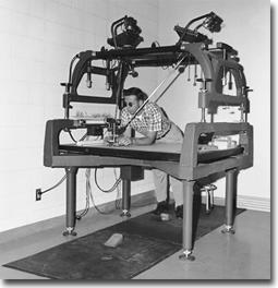
The Zeiss C120 Analytical Stereoplotter was a step closer to a totally automatic topographic mapping process. It was driven by an onboard computer and corrected for distortions in the aerial camera and film. The C120 combined each photo pair into a stereoscopic image and correlated the image to ground survey points to produce a digital topographic map.
Image
Seven Oaks Dam on the Santa Ana River above Redlands. A major feature of the $1.4 billion Santa Ana River Mainstem Project.
Surveying took another giant leap forward with the introduction of the Total Station in 1986. It combined theodolite, distance measurer and mini digital computer in a single, compact instrument. It measured distances and angles plus computed positions and elevations, while also storing the data. This instrument enabled the totally automated connection of points to produce maps, cross sections, profiles and land boundaries, all at a new level of cost effectiveness.
1987
By 1987, the District was ready to take the next logical efficiency step, the integrating of engineering, drafting, surveying and mapping. Purchase of a Computer Aided Design and Drafting (CADD) system made that integration possible. Also arriving on the scene at this time was the personal computer (PC). The District's first use of the PC was automating the drawing of record of survey maps, which proved to be a major time and cost saver. The combination of the PC and CADD provided a most powerful tool, augmented by a broad array of commercial and District developed software to support computer aided design and drafting directly on computer screens rather than on paper.
It was now possible to extract topography and cross sections from three dimensional "digital terrain models" (DTM's), and lay out proposed designs superimposed on screen electronically. Complex hydrologic, hydraulic, structural, survey and earthwork quantity computations were done in seconds, and evaluation of alternatives was accomplished with ease. Designs were finalized "on screen" and drafted on computer driven plotters, rendering hand drafting virtually obsolete.
The Temescal Creek Channel improvement project through Corona was completed in January 1987 at a cost of $7.5 million. District funding was augmented by Caltrans and Corona redevelopment monies.
1988 Historically, surveying had been based on ground monuments as fixed control points. Earthquakes, crustal motion, loss of fixed monuments, and the inability to feasibly replace or adjust monuments, required major change in survey ground control. In 1988, the District, along with the Riverside County Surveyor and with the support of the National Geodetic Survey, adopted the Global Positioning System (GPS), developed by the U.S. military. The system uses satellites 12,000 miles above the earth, in establishing precise ground position both horizontally and vertically.
1988
Historically, surveying had been based on ground monuments as fixed control points. Earthquakes, crustal motion, loss of fixed monuments, and the inability to feasibly replace or adjust monuments, required major change in survey ground control. In 1988, the District, along with the Riverside County Surveyor and with the support of the National Geodetic Survey, adopted the Global Positioning System (GPS), developed by the U.S. military. The system uses satellites 12,000 miles above the earth, in establishing precise ground position both horizontally and vertically.
1990
Saw the District attain an all time high of 196 employees. The design and construction of a new, more adequate, office building began at this time, with completion occurring in May 1991. A portion of the new 33,000 square foot building was leased to the Riverside County Waste Resources Management District.
Also in 1990, to implement the goals of the National Pollutant Discharge Elimination System (NPDES), instituted in the 1987 Clean Water Act, the District began monitoring the quality of stormwater runoff, especially during the critical initial phase of runoff. Automatic gages and samplers were situated in channels and underground storm drains to record storm runoff, in an effort to detect significant water quality problems.
Image

Introduced in 1986, the "total station" survey instrument automatically measured distances and angles and stored data, thus enabling a digital computer to economically produce maps, cross sections, profiles and land boundaries on a graphic plotter.
Image
The District's GPS continuously operating reference station (CORS) at Lake Mathews is managed jointly by the District and the Southern California Earthquake Center. The station utilizes satellites orbiting 12,000 miles above the earth to establish its precise ground position both horizontally and vertically.
1991
Tahquitz Creek, historically a flood threat to Palm Springs, was initially studied by the U.S. Army Corps of Engineers in the 1970's.. The Corps proposed a dam 40 feet high with a 400-acre-foot debris basin, plus 3.5 miles of concrete channel. Local environmental concerns and Agua Caliente Indian cultural objections caused the Corps to abandon the project and prompted the District to develop a modified plan. The concept was one of a more natural channel, a much lower dam with about 100 acre-feet of debris storage, a two mile reach of grass lined channel used as golf course, as well as bicycle and equestrian trails. The final project phase was completed in May 1991 at a cost of $12.2 million, of which $1 million was expended on recovery and documentation of Indian cultural resources.
1992
The District began the development of a Geographic Information System (GIS). This will be a spatially referenced set of data that can be retrieved and analyzed through desktop computers. It will be used to inventory and research existing and proposed facilities relative to underlying land characteristics such as property lines, ownerships, soil types, rainfall rates and environmental traits. The District's GIS will feature high positional accuracy, orthophoto backgrounds and scanned as built engineering drawings.
1993
During the two week period beginning January 5, 1993 over ten inches of rain fell on western Riverside county, resulting in seven deaths and causing more that $10 million in public property damage. Murrieta Creek flowing at a record 25,000 cubic feet per second (cfs), overflowed its banks and flooded Old Town Temecula at depths up to 5 feet resulting in $6 to 7 million in property damage. On February 3rd, the President declared the County a disaster area.
Aside from Murrieta Creek flooding in Temecula, other facilities throughout the District performed as designed, and prevented many millions of dollars in potential flood damage.
By February 1993, the second building of our new office complex was completed, adding another 27,000 square feet. About 30% of the normal cost to build comparable office quarters was saved by utilizing concrete "tilt-up" construction on both buildings.
1994
After several years of construction plan preparation, including re-reviews of the project feasibility, the Corps started construction of the Lake Elsinore Outlet Channel in 1993, which included enlargement and improvement of the outlet channel from the lake to Riverside Drive, five new bridges across the channel, and a debris basin and channel in Wasson Canyon, a major tributary to the Lake Outlet Channel. The project was completed and dedicated at a ceremony in Lake Elsinore in October 1994.
This project limits the 100 year lake flood elevation to 1263.3, which is 5.7 feet less than the pre-project condition and frees up about 207 acres of land for valuable lake front development.
Oak Street Channel, Corona, had its first stage of improvement in 1958 and its final project completion, as part of the Federal Santa Ana River Mainstem project in June 1994 at a cost of $23 million, of which the Corps of Engineers contributed $13 million.
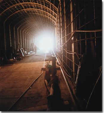
Micro-tunneling is a concept first developed in Europe and first utilized in the United States in the mid to late 1980's to tunnel under existing operating structures through soft ground (not hard rock) with fairly shallow cover.
Image
Two new office buildings, totaling 60,000 square feet, were completed in May 1991 and February 1993, on the existing site purchased in 1960. Location is Market Street at the 60 Freeway, Riverside.
Image
Significant rainfall during the first half of January 1993 that saturated the watershed, followed by a very intense storm on January 16, resulted in devastating flooding along Murrieta Creek. Flood damages in the cities of Murrieta and Temecula approached $10 million, with considerable damage downstream at Camp Pendleton Marine Base in San Diego County.
The Oak Street Channel project involved crossing the 91 Freeway without interrupting traffic and the Day Creek Channel crossed the Union Pacific Railroad near the railroad overcrossing of the 60 Freeway without interrupting rail traffic. The only option initially available for both of these projects was "jacking" a very large concrete structure under the freeway and railroad. "Jacking" is a term for pushing a structure through the ground, excavating soil just ahead of the structure as it is being pushed. Because of the enormous forces and unknowns in pushing such a large structure, the District investigated and decided that micro-tunneling was a viable option and allowed the contractors to bid that method of construction for the Oak Street Channel crossing of the 91 Freeway and the Day Creek crossing of the Union Pacific Railroad. Our projects were the fourth or fifth time this method of tunneling was used in the United States. Both projects were successfully completed using micro-tunneling.
1995
Having ably served the District for 34 years, and as its Chief Engineer for 17 years, Kenneth L. Edwards retired in December of 1995. Under his guidance the District experienced phenomenal growth in staff and projects completed. Beginning his tenure concurrently with passage of Proposition 13 presented a real challenge. The District suffered a 60 percent reduction in projected property tax revenue for Fiscal Year 1978-79. In spite of this funding limitation the rapid rate of development expanded the tax base, and a schedule of fees levied on private developers plus special assessments provided monies to construct about $230 million in flood control facilities, during his term as Chief Engineer.
The District's inventory of constructed projects now includes 191 miles of channels, 42 miles of levees, 185 miles of underground storm drains, 16 flood control dams, 24 flood retention basins, 5 debris basins, 289 miles of access roads, 207 miles of chain link fencing, all on more than 5000 acres of project right of way.
Maintenance procedures have progressed over the years to the point where a sophisticated computer program triggers periodic inspections and routine maintenance. The program also records maintenance activity on each project and the nature of the work accomplished along with associated costs. Mechanized equipment has seen many advances and yet much hand work is still required in such activities as trash collection, fence installation and rodent control. Weed control is a critical element of the maintenance program and relies on the use of highly effective chemicals which are much less toxic than those used in the past and are environmentally safe. The newest alternative method for weed control is mowing the growth areas with track mounted mowers when spraying is not a viable option.
Image
Construction inside the Oak Street Channel culvert under the 91 freeway at Corona.
Image
Sediment from undeveloped areas upstream flows through the high velocity portions of University Channel only to settle in areas where the velocity slows. Maintenance personnel remove material to maintain channel capacity.
The Techno-Boom Years
1996
Twenty-seven years after joining the District staff, David P. Zappe was appointed Chief Engineer in March 1996. Mr. Zappe is a prime example of one "rising through the ranks". His engineering and managerial talents took him from college graduate and Junior Engineer in 1969 to Principal Engineer in 1985, Assistant Chief Engineer in 1992 and Chief Engineer in 1996.
The next several years proved to be a time of giant leaps in technology, not just at the District, but across the nation. In hindsight, we see that Mr. Zappe’s tenure from 1996 through 2002 as Chief Engineer seemed to coincide with the world-wide techno-boom. While EBay™ and Google™ were becoming household terms, the District was busy building an arsenal of technology that enabled us to do our jobs better, faster, and more accurately; ultimately allowing the District to improve our public services at a reduced cost, while concurrently becoming a leader in mapping southern California.
In 1996, the District began scanning aerial photography into digital imagery for map-making, because having an accurate representation of the ground surface elevation is critical to any project—public or private. Therefore, the District scanned over 1,700 photos from the 1995 western Riverside County GIS Flight which commenced our large-scale database and catapulted the District into the digital age.
The District houses an impressive historical aerial photo library that is open to the public, and we reproduce photos for developers and other public agencies at a nominal cost.
Image
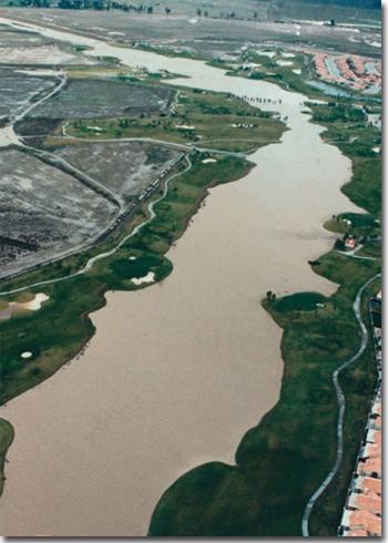
Salt Creek Channel was designed with gentle slopes and a soft bottom to accommodate its use as a golf course, while maintaining the capacity to carry a hundred-year flood.
The District also began gathering survey data 24 hours a day, every day, using GPS to assist the National Geodetic Survey with their Continuously Operating Reference Stations (CORS). The CORS network is a multi-purpose cooperative endeavor involving government, academic, and private organizations. The sites are independently owned and operated. Each agency shares their data with the National Oceanic and Atmospheric Administration (NOAA), who in turn analyzes and distributes the data free of charge.
After record rainfall in 1993 and substantial flood damage in the Temecula/Murrieta area, in 1996, the District, in conjunction with the U.S. Army Corps of Engineers (Corps), completed construction of the Murrieta Creek MDP Line F and Line F-1, at a cost of the $1.9 million. Furthermore, a Letter of Map Revision (LOMR) was obtained from FEMA for this project the following year, which resulted in flood insurance rate reductions for many residents of the Old Town Temecula area.
After many years in the making, the Salt Creek MDP was adopted in 1996. The MDP covers an 8.2-mile reach of Salt Creek between the City of Hemet and Winchester. The drainage area is approximately 89 square miles and the cost of implementing the MDP was approximately $13.5 million.
Other construction projects completed in 1996 include the Arlington Channel Stage 4, and the Perris Valley Channel Lateral A.
1997
Construction of the Whitewater River Right Bank Levee, Stage 2 project was completed in November 1997. The project included construction of 6.7 miles of levees on the right bank from Indian Avenue to Avenue 34. Subsequently, the District’s Floodplain Management Section completed a LOMR (Letter of Map Revision) which removed hundreds of residents from FEMA's previously mapped floodplain, and in-turn reduced the cost of flood insurance for those residents. Other construction projects completed in 1997 include the Southwest Riverside Line C5 and Line C6, and Wildomar Lateral E.
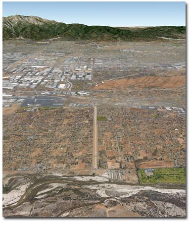
Image
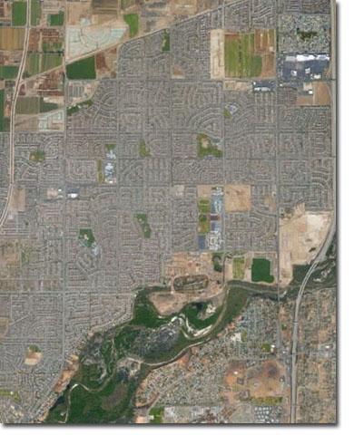
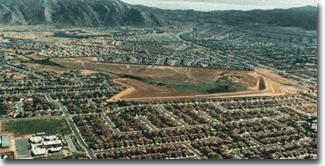
Eastvale 2015; Source: Google Earth
1998
The Eastvale MDP was adopted by the Board of Supervisors in 1998, and was later updated in 2002. The MDP drainage area is approximately 8 square miles and collects flows from local runoff then transports them to the Santa Ana River and Cucamonga Creek. As of 2015, approximately 90% of the facilities within the Eastvale MDP have been built and are fully functional.
1Other projects completed in 1998 include Sunnyslope Channel Stage 7; Perris Valley Line J, Stage 3; and Sunnymead Line M4 and Line B7.
1999
The Seven Oaks Dam was complete in 1999. The Seven Oaks Dam Project was over 30 years in the making via monumental collaboration between the District, the U.S. Army Corps of Engineers, and the Counties of Riverside, Orange and San Bernardino. At the time it was constructed, Seven Oaks ranked as the sixth tallest dam in the U.S. Today the U.S. Army Corps of Engineers is undergoing feasibility studies to convert the dam to a dual use flood control facility and retention basin for water conservation.
Other projects completed in 1999 include the San Sevaine Channel Stage 8; Winchester Line F; Moreno Line 1, Stage 2; Indian Canyon Debris Basin; and Perris Valley Channel Stage 1.
2000
In 2000, District employees were connected to the World Wide Web to conduct research and development. Little did we know that the internet would become such a valuable resource not only for internal use, but also for keeping the public apprised of District projects, notices and services provided.
Construction projects completed in 2000 include South Norco Channel Stage 3 and Line SA; Palm Canyon Channel Stage 5; Day Creek/Martin Creek Storm Drain; Pedley 64th Street Storm Drain; and Southwest Riverside Line G Stage 1.
2001
In 2001, the District completed the Compton Avenue Storm Drain Phase 2 project. This project was the District’s one and only project designed using the “International Metric System”. Other projects completed in 2001 include Norco Line ND and Lateral ND1; and the Beaumont Palm Elementary School Detention Basin Stage 1.
2002
Construction projects completed in 2002 include Corona Storm Drain Line 7A, Stage 1; Belltown Line D, Stage 1; Pedley 64th Street Inlet Modifications; Sunnymead Line D, Stage 3; and Homeland Line 2.
Image
Seven Oaks Dam
Image
This is a rare site as Seven Oaks Dam does not usually retain substantial water, other than during large storm events. This photo was taken in 2010 when the Corps was conducting routine testing of the facility.
A Changing of the Guard and the Unpredictable Economic Rollercoaster
Warren D. “Dusty” Williams took over as General Manager-Chief Engineer in January 2003. Dusty was another long-timer that worked his way up the ranks from Student Intern and Junior Civil Engineer all the way to the Chief. At the time of his appointment in 2003, Dusty had been with the District for 28 years.
Dusty’s personal philosophy on life can be summarized in three simple statements:
- Do the right thing.
- Do the best you can.
- Always treat others the way you want to be treated.
However, his words of wisdom do not end there… His leadership philosophy and managerial style are illustrated with more words from the Chief himself:
A leader has earned the respect of others because of his or her actions and character. He does not dictate nor command the actions of others directly but is looked to for guidance, especially in times of stress…. Every great organization needs both managers and leaders… We follow our managers because we have to; we follow our leaders because we want to.”
“I purposefully use the phrase ‘our job’ as an indicator of our singular purpose – protecting people, property and watersheds. Yes, some of us work in an office setting, while some of us work outdoors; some of us plan, while some of us do; some measure rainfall, while some measure yards of concrete; some spend money while others predict and track the spending. The point is that while we all have our specific duties and assignments, all of those are just part of the BIG picture – flood control and water conservation.”
“I believe "we" are obligated to provide as much input as possible into regional, state and federal policy to ensure the interests of Riverside County are represented and protected.”
“The world changes and moves forward — organizations must also change or they will become irrelevant, or worse, extinct.”
And lastly…“Hire good people, and get out of their way…”
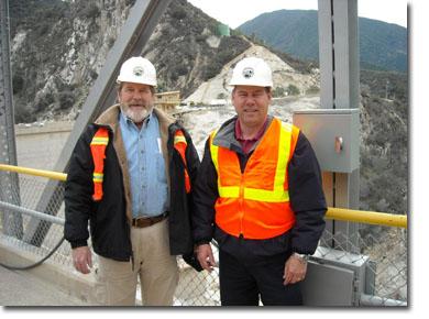
Image
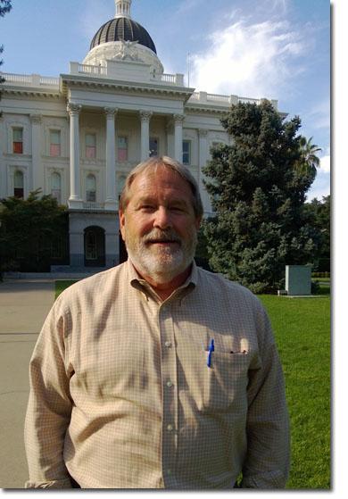
General Manager-Chief Engineer, Dusty Williams at the California State Capitol in Sacramento; Source: Stormwater; Jan 16, 2014; C. Brzozowski
Most importantly, Dusty understands that we cannot control floods, but we can try to manage that risk via two ingenious approaches:
- Keep the water away from the people; and
- Keep the people away from the water… enough said!
All kidding aside… under Dusty’s leadership, the District has been integral in shaping federal, state and local policy related to levee safety and flood risk management. He has a long-standing history of taking on the tough issues, such as helping the politicians on Capitol Hill understand that the arid southwest is not the same as the Mississippi floodplain, and that we need flexibility in the regulations to account for such.
Back in 1978, the District was a founding member of the National Association of Flood and Stormwater Management Agencies (NAFSMA). Dusty has been a member of the NAFSMA Board of Directors since 2006 (serving as President 2013 through 2014) and has continuously represented state and local public agencies nationwide. NAFSMA is a local and regional public agency driven organization based in the nation’s capital, with a focus on effective flood and stormwater management in urban areas, including emergency management practices, and water quality protection.
Additionally in 2008, Dusty was appointed to the National Committee on Levee Safety (NCLS). The NCLS is a committee of federal, state, local, and private sector members with a Congressional mandate to prepare recommendations and a strategic implementation plan for a National Levee Safety Program. Through this appointment and the District’s association with NAFSMA, Dusty continues to lobby Washington D.C. on a number of water and flood risk management issues of national importance, such as the fact that our levees in the arid southwest are not subject to the same and flows as those in other parts of the U.S., and therefore, we need flexibility and special standards and/or exceptions in federal legislation commensurate with our arid regional climates.
In 2003, the District completed the construction of the Nason Basin in Moreno Valley. The 16-acre basin reduces the 100-year flows by more than 70%, and amongst others, protects a high school and the County hospital from large storm events. Other projects completed in 2003 include Day Creek Lateral A-2; and Eastvale Line E, Stage 1 and Stage 3.
2004
This was a busy time for the District, local municipalities and other government agencies. Housing and private development projects were moving at a sprinters pace and surely much faster than the cities and local agencies could keep up with, including the District. In 2004 alone, 439 land development cases were reviewed by the District for stormwater and drainage compliance, while 317 were approved. This proved to be a peak in the development market as around this same time frame, the District’s Floodplain Management Section had 10 times the normal amount of “floodplain” cases, peaking at 350 in 2005, as compared to only 34 cases in 2000 and only 13 cases in 2012.
Image
Nason Basin in Moreno Valley
Relentless storms in 1993 caused Murrieta Creek to overtop its banks and the city of Murrieta and Old Town Temecula were severely flooded, causing millions of dollars in damages. Subsequently, in 2000, Congress authorized the Murrieta Creek Flood Control, Environmental Restoration and Recreation Project with an estimated total cost of $90 million. The project is a joint effort between the U.S. Army Corps of Engineers with the District as the Local Sponsor. This monumental project is approximately seven miles in length from Temecula Parkway in Temecula to Tenaja Road in Murrieta. The project includes a 270-acre multi-purpose detention basin of which 160 acres will be dedicated to environmental restoration and 50 acres dedicated for a sports park. The project was planned to be constructed in multiple phases over several years. In 2004, the Corps completed construction of Phase I from Temecula Parkway to 1st Street. Although the Phase II ground-breaking ceremony took place in December 2014, the Corps is expected to commence construction of a portion of Phase II in 2015 primarily using local funds, while the District works diligently to secure federal funding to complete the construction of Phase II up to Winchester Road.
The 1983 San Sevaine Channel Master Plan was completed in full in 2004 when Stage 7 was constructed. The San Sevaine Channel System begins in the San Gabriel Mountains in San Bernardino County and ends at the Santa Ana River in Riverside County. The system is approximately 13 miles long, from the mountains to the river, with some sections as much as 50 feet wide. The completed channel system provides 100-year flood protection for public roads and schools, the Union Pacific Railroad, multiple utilities, and substantial residential, commercial and industrial developments. The original 1983 estimated cost of construction for the Riverside County portion was $12 million dollars, yet the actual cost of construction cost over the 20-year build out totaled approximately $15 million.
Other construction projects completed in 2004 include Salt Creek Channel Stage 6; Four Corners Storm Drain Stage 4; and Norco Line NA-S, Stage 2.
Image
San Sevaine Channel draining to the Santa Ana River
In 2004, the District’s Mission Statement was revised as follows:
“The mission of the Riverside County Flood Control and Water Conservation District is to protect people, property and watersheds from damage or destruction from flood and storm waters and to conserve, reclaim and save such waters for beneficial use.”
At that same time the District updated its philosophy for fulfilling the new Mission Statement:
“Strive for excellence with integrity – Earn respect of the public, other engineering organizations and policy makers – Require accountability at all levels – Accord respect, recognition and trust to all – Maintain open communication at all levels – Effectively implement the District’s mission statement.”
2005
Some construction projects completed in 2005 include San Jacinto Line E, Stage 2; Hemet Line D, Stage 3; and Southwest Riverside Line C, Stage 5.
In October 2005, the District’s staff played an integral role in the 1st Annual California Stormwater Quality Association (CASQA) Conference in Ontario, California. The District continued to be active in the association in dealing with statewide stormwater issues, with several District staff serving on the Board of Directors, including Steve Stump, Mark Wills, and Jason Uhley.
2006
The 2.7-mile County Line Channel was completed in January 2006. This facility is located in the Eastvale area along the San Bernardino-Riverside County Line where historically dairies were the primary land use and manure-laden runoff polluted our waterways. The project was a collaborative effort by the District, San Bernardino County Flood Control, the City of Ontario, and the Santa Ana Regional Water Quality Control Board. The County Line Channel significantly reduces the water pollution, and facilitated the construction of a comprehensive drainage network for the then-future City of Eastvale.
The Homeland MDP and the Romoland MDP were both revised in 2006. The drainage area covered by the Homeland MDP is approximately 6.6 square miles, whereas that of the Romoland MDP is approximately 11.1 square miles. Both systems outlet into the San Jacinto River. The estimated cost of implementing Homeland MDP is approximately $30.5 million, and that of the Romoland MDP is approximately $64 million.
Image

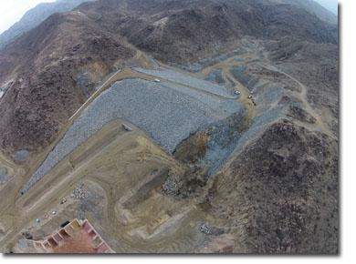
In 2006, the District completed the Gavilan Hills/Smith Road dam and debris Basin. The $4.5 million project included 3,600 feet of concrete rectangular channel and a debris basin at the upstream end. This was one of the District’s first major projects using soil cement. This project is significant not only because it reduces the flood risks for downstream residents, but it also retains sediment that would otherwise end up polluting Lake Matthews. Furthermore, this project included an extraordinary 20-acre onsite mitigation project that was required to offset the environmental impacts of building the dam. The Gavilan Hills mitigation project took 10 years from conception to completion, and in 2014 was deemed a “model mitigation project” by the Santa Ana Regional Water Quality Control Board.
Other construction projects completed in 2006 include the Perris Valley Channel Lateral B, Stage 2; El Cerrito/Kanye Street Storm Drain; Hemet Line D, Stage 6; and the Mission Lakes Levee. The District also expanded its maintenance facility with a much-needed garage to house our operation and maintenance equipment. The $1.2 million expansion nearly doubled the overall amount of square footage available for equipment repairs and storage.
2007
The District joined the Santa Ana Watershed Project Authority for the "One Water, One Watershed” (OWOW) program. The OWOW program focuses on “integrated water management” for the Santa Ana River through collaboration of the tri-county stakeholders into one team committed to providing water for sustainable economic growth, exceptional quality of life, and a healthy environment.
Projects completed in 2007 include Corona Line 7A, Stage 2; Corona Line 46, Stage 1; Hemet Line D, Stage 4; Day Creek Channel Stage 6, Phase 1; La Sierra Cypress/Campbell Lateral, Stage 1; and Wildomar Channel, Stage 5.
2008
In alignment with the national economic downturn, the District had a noticeable slowdown in construction in 2008. Although we had some active construction projects, none were completed in 2008 and only few projects were completed in 2009 and 2010.
Image
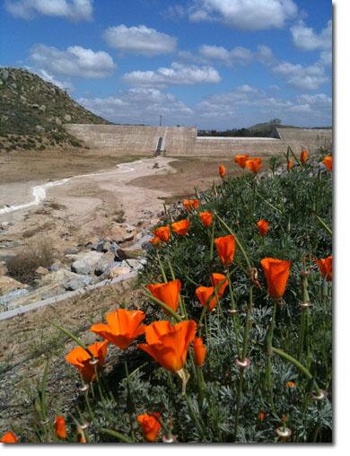
Gavilan Hills/Smith Road Dam and Debris Basin in background; The California poppies were planted as part of the onsite wetlands mitigation.
2009
The District began to automate level-monitoring devices at District dams, which allows the District’s Emergency Storm Center to remotely monitor water levels behind the dams during severe storm events.
2010
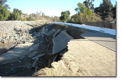
In December, southern California received record rainfall and severe flooding. The damages in Riverside County were severe—Mockingbird Canyon Road washed out at several locations, the Corona Main Street dam spillway overtopped; and the spillway at Sycamore Dam, (built in the 50s), overtopped for the first time ever.
As a result of the December storms, the State declared an emergency for numerous counties including Riverside County, and the following month, President Obama declared the County a “major disaster area” which made federal funds available for the District to do emergency work and repair or replacement of infrastructure damaged by flooding and debris and mud flows.
Construction projects completed in 2010 include the Monroe Retention Basin Rehabilitation; and the Gavilan Hills Wetlands Habitat Creation Project. Stage 1, which was required by the wildlife resource agencies for impacts from constructing the Gavilan Hills/Smith Road Dam and Debris basin.
Residents who live in FEMA mapped floodplains are required to pay flood insurance depending on the level of flood risk present on their property. Since 2010, the District has worked aggressively toward getting an insurance discount for these residents under the National Flood Insurance Program's Community Rating System (CRS). CRS is a voluntary incentive program that recognizes and encourages local floodplain management practices that exceed the FEMA’s minimum national requirements. Effective 2015, the District is in the process of improving our CRS status, and we expect to achieve even greater savings for County residents in the near future…stay tuned!
Image
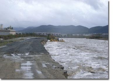
These photos were taken during the December 2010 floods. Above: Mockingbird Canyon Road;
below: Murrieta Creek..
Image
Bouncing Back...A Lot of Dam Construction
The District started to bounce back and made significant progress in 2011 with the completion of multiple construction projects such as Calimesa Avenue L Storm Drain, Stage 1; Palm Canyon Wash Levee and Channel Restoration; Menifee/Hawthorn Storm Drain, Stage 1; Norco Channel Lines NA-3 and N-1, Stage 2; Pedley Hills Bolero Storm Drain, Stage 1; and the Palm Canyon Levee Restoration, Stage 91. In addition, the District, in conjunction with the US Army Corps of Engineers, completed construction of the Santa Ana River Below Prado Reach 9 Option A Mobile Home Levee.
The District released its Low Impact Development (LID) Design Manual in 2011. This was a huge effort to provide public agencies and private developers water quality best management practices using the latest science and the best available technology.
The District’s 15-acre headquarters was retrofitted in 2011 with LID features and water conservation measures as part of a demonstration and testing project funded by the District with Proposition 13 grant support from the State Water Resource Control Board and the Santa Ana Watershed Project Authority.
The LID project promotes sustainable design and contributes to water banking; stormwater capture and management; stormwater quality enhancement; and water conservation using LID Best Management Practices (BMPs) based on the District’s 2011 LID BMP Design Manual, such as replacement of 10,000 square feet of existing asphalt pavement with porous asphalt, porous concrete pavement and subdrain systems; installation of 38,000 square feet of porous pavers; installation of infiltration basins, biofiltration swales and planter boxes; construction of ten water quality and flow meter monitoring vaults; and conversion of five acres of turf to California-friendly landscaping with reclaimed water ready-drip irrigation systems and “smart” irrigation controllers.
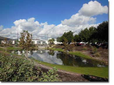
The District currently owns, operates and maintains over 600 miles of channels, storm drains and levees along with 74 dams and detention basins. These facilities not only reduce flood risks to the residents of the District, but because of the nature of our arid environment, during dry times many of our open facilities also serve the public as trails, parks and golf courses, among other things. Additionally, we are continuously discovering more ways to utilize these facilities to capture storm water to help us address the water needs of our region.
The project also incorporates monitoring elements into the design of the site, and the District's headquarters serves as a regional LID demonstration and education facility for developers, regulators, environmentalists, students and other interested stakeholders, and is available for public tours.
Our LID project is one of the only projects in the state that was designed from the ground up to facilitate accurate analysis of water quality, hydrologic and water conservation. The District is very proud of our LID demonstration project and has been the recipient of various awards including:
- 2012 Civil Engineering Project Improvement Award from the American Society of Civil Engineers (ASCE) San Bernardino/ Riverside Branch
- 2012 Challenge Award from the California State Association of Counties (CSAC)
- 2012 Stormwater Quality Project of the Year from the American Public Works Association (APWA) Southern California Chapter
- 2013 Outstanding Stormwater Management Award from the American Society of Civil Engineers (ASCE) San Bernardino/ Riverside Branch
- 2013 City of Riverside’s 27th Annual Beautification Award for Exterior Reconstruction with Landscaping, from Keep Riverside Clean and Beautiful
The District hosted a ribbon-cutting ceremony to officially open the LID facility in May of 2012. Guest speakers included Board of Supervisor, Marion Ashley; SAWPA General Manager, Celeste Cantu; and Santa Ana Regional Water Quality Control Board Chief Executive Officer, Kurt Berchtold.
2012
Realizing that there is power in numbers, in 2012, the District helped establish an informal coalition with six other counties (Santa Barbara, Ventura, Los Angeles, Orange, San Diego, and San Bernardino) to focus on issues unique to Southern California. Together, this 7-County Coalition has more than 21 million residents (half of the state’s population); 32 Congressional Districts; over $1 trillion in gross domestic product; $2.4 trillion in property value; vital goods movement ports and corridors; and federal regulations that are often not suitable to our arid southwest climate. To that end, the Coalition began aggressively lobbying for funding support and legislative action, such as provisions for “levees” that are more representative of our region, as opposed to applying the same standards needed to protect New Orleans, Sacramento, or the mid-west—the nature of southern California flooding and infrastructure is different and we need to treat it as such.
Image
Above: LID on-site detention basin; the structure in the background is the LID Data Collection Center.
Below: LID garden with drought-tolerant plants.
Image
Construction projects completed in 2012 include the Corona Storm Drains, Ontario Avenue Stages 1 and 2, and Line 1G; Day Creek/Frank Avenue Storm Drain; Homeland Line 2, Stage 2; La Sierra and Arlington Channel Repairs; Cabazon and Montgomery Channel Repairs; and the San Jacinto North Levee Repair; and the District completed its award winning Low Impact Development (LID) project mentioned earlier.
2013
The District completed the Day Creek Channel system, which conveys a 100-year flow of 10,000 cubic feet per second, and provides flood protection from the San Gabriel Mountains (in San Bernardino County) to the Santa Ana River.
Upon completing Day Creek Channel system, the District worked closely with FEMA to update the related Flood Insurance Rate Map (FIRM), which in turn, removed 127 homeowners from the floodplain. In conclusion, effective November 2013 those homeowners were no longer required to purchase flood insurance, although they could still voluntarily purchase insurance, but at a much lower rate!
Image
Day Creek Channel in Jurupa Valley
Other projects completed in 2013 include the Calimesa Avenue L Storm Drain, Stage 2; Lakeland Village Orange Street Lateral, Stage 1; and the Mira Loma Beach Street Storm Drain, Stage 2.
Late in 2013, the District commenced construction on the Arroyo Del Toro Channel in Lake Elsinore. The project was unique in that there was an above-average potential to encounter human remains during construction because of its location adjacent to an existing cemetery. Therefore, the District used specially-trained cadaver dogs prior to breaking ground to locate any human remains, but we are happy to report that none were found. To be conservative, we also hired a qualified archeologist to monitor the site during construction. Nonetheless, the job went off without a hitch and was completed in 2015.
In 2013, the District began preparing dam inundation studies as part of an effort to create Emergency Action Plans. These plans will allow for orderly evacuation procedures to keep the public safe from harm. As an upgrade from previous inundation studies performed in the 1970s, two dimensional modeling is used to provide more accurate inundation limits.
Image
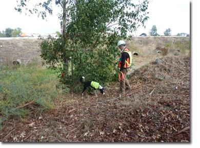
The Arroyo Del Toro project in Lake Elsinore required special handling and help from cadaver dogs due to the potential to find human remains near the project site.
2014
The Murrieta Creek Phase II groundbreaking took place in December 2014 and the District celebrated with the U.S. Army Corps of Engineers and elected officials. Other projects completed in 2014 include North Norco Laterals N-1D and Spirit Knoll Court; and Sunnymead Line P-6, Stage 2 and the Corps’ Santa Ana River Below Prado Reach 9 Phase 2B project.
In March 2014, Press Enterprise writer Bob Pratte, authored a tongue-in-cheek column in which he noted:
“[…The Flood Control District] spoils the rainy day fun around town by building storm drains... Historically, intersections all over the San Jacinto Valley flood during storms, creating the spectacle of cars masquerading as submarines, but new storm drain projects are ruining the fun.”
For the 23rd straight year, in May 2014, the District proudly accepted a "Certificate of Achievement" for "Outstanding Financial Reporting for the Comprehensive Annual Financial Report (CAFR)" from the Government Finance Officers Association.
Although his article intended to be a lighthearted perspective of the drainage problems that have plagued the Hemet and San Jacinto area for years, the District was quite pleased with Mr. Pratte’s accurate observations. It was one of the few times that our planning and efforts were publicly celebrated for doing well, albeit indirect—the District was happy to take the compliment!
At the end of 2014, Stephen C. Thomas, the Assistant Chief Engineer (ACE) retired after 33 years with the District. Steve began his career with the District in 1981 as a Junior Engineer. Over the next two decades, Steve climbed the engineering ladder and was eventually promoted to Chief of Operations and Maintenance in 2003. He served in that capacity until January 2008 when he was tapped by Chief Williams to become the District's 9th Assistant Chief Engineer. Steve had been an essential part of the District’s success and his send-off was bittersweet.
With Steve’s departure, Jason Uhley, the former Chief of Watershed Protection, was promoted to take on the very important position of Assistant Chief Engineer. With 19 years of service to the District; 12 of which as a Senior Civil Engineer managing the NPDES program, followed by 5 years as Division Chief managing the Watershed Protection Division; knowledge acquired through his MPA; and his work with numerous professional organizations, Jason’s contribution to the District will undoubtedly be successful!
Image
Dusty Williams (left) and former ACE, Steve Thomas (retired 2014)
2015
After more than 20 years from conception to completion, the Eagle Canyon Dam and Debris Basin project commenced construction in 2013 and is expected to be complete in 2015. This facility will provide flood protection to dozens of properties in Cathedral City. Historically, during periods of heavy rainfall, mud and debris would funnel down Eagle Canyon and damage property located immediately downstream of the canyon, as in July 2008 and more recently in August 2012. This project has included substantial environmental and regulatory involvement because of the potential to adversely impact Waters of the U.S. and habitat for endangered species such as bighorn sheep.
The Lakeland Village MDP was adopted early in 2015. The Lakeland Village drainage area encompasses approximately 13 square miles and includes 16 separate watersheds. The plan is intended to collect storm flows emanating from all 16 watersheds and convey them safely to Lake Elsinore. The estimated cost to construct the MDP is approximately $48 million.
The Moreno MDP was revised in 2015. The Moreno MDP encompasses the eastern portion of the city of Moreno Valley and portions of the surrounding unincorporated Riverside County lands. The drainage area is approximately 21 square miles and the MDP facilities include approximately 30 miles of channels and storm drains and five basins. The estimated cost of implementing the Moreno MDP is $160 million.
Image
Eagle Canyon Dam in Palm Springs and Cathedral City; Photo taken in December 2014 by Claudio M. Padres during final stages of construction.
Projects expected to be complete in 2015 include Eagle Canyon Dam; Romoland Line A, Stage 3; San Jacinto Lines B, C, C4, C5; and Pyrite Channel Bypass and Channel Storm Drain, Stage 1; North Norco Channel, Stage 10; Gilman Home Channel, Stage 90, and Lateral A Stage 3; Temescal Creek Foster Road Storm Drain, Stage 1; West End Moreno Line LL; and the San Jacinto MDP.
Looking ahead, we expect the following projects to be completed in 2016: Little Lake Line B; Stage 1, and Hemet Line D; and Palm Springs Line 43 and Lateral 43A; while, Romoland Line A, Stages 4, 5 and 6 will be well underway, but likely not complete until 2017…
Moving Forward with a Greater Focus on the Environment and Water Conservation
As we celebrate our 70th anniversary, the Chief Engineer, has a clear vision and understanding of our issues, challenges and the path ahead. It’s clear that flood control/flood risk management is no longer a local issue. In fact, federal and state environmental, safety, and water quality regulations have a profound effect on the District, which is why Dusty works diligently to influence state and federal policy and legislation.
It is also apparent that for the greater part of our existence we were mainly focused on the Flood Control portion of our name. However, as the new century dawned, it became clear that we could no longer be our fathers’ flood control agency. That is not to say we have abandoned our focus – rather we have expanded it.
Although we remain dedicated to flood control management and public safety, we are happy to strengthen and embrace a more environmentally-friendly culture with a greater emphasis on water conservation and "Integrated Water Management".
While "Integrated Water Management" is a relatively new term, it is not a new practice. In fact, this practice is something the District has embraced for years–we just didn’t call it that. We’ve been recharging groundwater behind some of our dams since the 60s. Since 1971, Don Lorenzi Park (in Riverside) has been serving the recreational needs of the local community except during major rain events when instead it provides flood relief to the surrounding neighborhoods. Many of the beautiful lush golf course fairways in Coachella Valley double as major flood conveyance ways during storm events.
The District currently owns, operates and maintains over 600 miles of channels, storm drains and levees along with 74 dams and detention basins. These facilities not only reduce flood risks to the residents of the District, but because of the nature of our arid environment, during dry times many of our open facilities also serve the public as trails, parks and golf courses, among other things. Additionally, we are continuously discovering more ways to utilize these facilities to capture storm water to help us address the water needs of our region.
These are just a few examples of the multi-use facilities that have been a part of this District’s repertoire for years. Nonetheless, while the concept is not new to us, we cannot just sit back and point to accomplishments of the past — we must instead keep doing Integrated Water Management and we need to find ways do it more; more often and more robustly.
Water conservation, on the other hand, has historically taken a back seat in terms of what we do as a District. However, as flood control facilities continue to be built-out and environmental conditions like climate change and drought continue to become increasingly important issues, the significance of water conservation projects and sustainable groundwater management will continue to elevate as we move into the future. With California currently experiencing a drought of epic proportions, the District has increased its focus on water conservation projects and teaming opportunities with local water agencies.
In addition, for many years the District has worked closely with state and federal natural resource agencies to reduce flood risk, while maintaining delicate ecosystems, unique habitats, and endangered species, and we are an active Permittee to both the Western Riverside County and the Coachella Valley Multiple Species Habitat Conservation Plans. Nonetheless, with the onset of steeper regulations and a greater emphasis on environmental protection, the District will continue our dedication to being a role-model steward for environmental protection.
Image
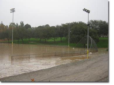
Monroe Basin/Don Derr Park during 2010 storms.
Furthermore, although the National Pollutant Discharge Elimination System (NPDES) is federal law, in California, it is enforced by the State Water Resources Control Board through its nine Regional Boards via MS4 permits (Municipal Separate Storm Sewer System permits). Riverside County is unique in that we are located within three different watersheds and, therefore, hold three separate MS4 permits, each issued by a separate Regional Board: Santa Ana, Santa Margarita, and Whitewater.
The District, the County of Riverside, 23 Riverside County Cities (excluding Blythe), and the Coachella Valley Water District have joined forces for joint NPDES MS4 permits, which enables the "co-permittees" to share resources, eliminate duplicate efforts, and minimize program costs. Due to our position as a regional flood control facility owner and operator, the District is the “Principal Permittee” for all three MS4 permits. With environmental awareness and conservation issues at the forefront, requirements for each permit renewal have generally become steeper and more stringent, requiring more effort and resources.
As of 2015, the District continues to collaborate with the co-permittees to comply with the three MS4 permits by providing training and public outreach throughout the County, participating in regional projects with neighboring county government groups, and monitoring statewide water quality issues to help streamline NPDES program implementation. However, little did we know back in 1990 that the NPDES program would become such an enormous District responsibility requiring substantial resources and increased partnerships with public and private entities.
Image
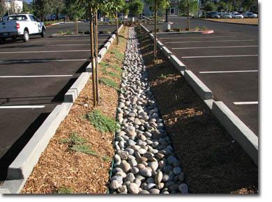
Water quality feature in a Temecula parking lot.
A few final thoughts…
We will always keep public safety at the top of our list, but by being clever we can also incorporate water conservation, recreation, habitat corridors, environmental restoration and water quality features into our facilities.
With the onset of steeper regulations and a greater emphasis on environmental protection, the District is dedicated to being a role-model steward for environmental protection.
And lastly, with nearly $200 million in construction projected over the next four years, you will see that we are destined to spoil even more of Mr. Pratte’s fun in the next several years.
Image
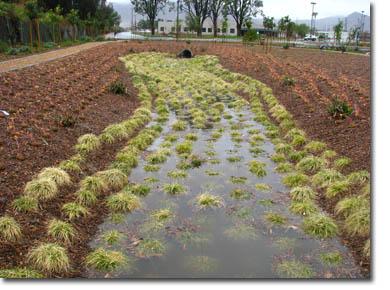
Water quality feature (biofiltration basin) included in the District’s LID demonstration project.