
Understanding Regulated Floodplains
County Ordinance 458 regulates three types of floodplains within Unincorporated Riverside County
1. FEMA
Current Zone Designations (as of August 28, 2018)
Regulated Zones
A -
Approximate 1%-annual chance floodplain. No base flood elevations [BFE]
AE, without floodway -
1%-annual chance floodplain based on a detailed study. Base flood elevations are provided and can be found on the Flood Insurance Rate Map [FIRM] and the Flood Insurance Study [FIS] profiles.
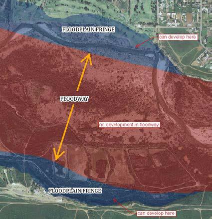
AE, with floodway -
Same as AE but the floodplain is separated into two regions: floodplain fringe and floodway. Development is allowed within a 1%-annual chance floodplain but new development creates obstruction to flood flows that raise the water surface elevation. To limit this surcharge to 1.0-foot, a “floodway” is designated which restricts development to only the areas outside of the floodway [i.e. floodplain fringe, see Figure 1].
AO -
Areas of shallow 1%-annual chance flooding [1 to 3 feet depth]. This is a detailed floodplain depicting sheet flow on sloping terrain. Instead of a base flood elevation, average depths within the floodplain as shown on the Flood Insurance Rate Map. For areas of alluvial fan flooding, velocities are also provided.
AH -
Areas of shallow 1%-annual chance flooding [1 to 3 feet depth]. This is a detailed floodplain depicting areas of ponding. Base flood elevations are provided on the Flood Insurance Rate Map.
Shaded X -
Represents 1 of 4 things:
- 0.2%-annual chance floodplain
- Area between the limits of 1% and 0.2%-annual chance flood
- 1%-annual chance floodplain with average depth < 1 foot or having a drainage area less than 1 square mile
- Areas protected by levees from the 1%-annual chance flood
Unshaded X -
Areas outside of 0.2%-annual chance floodplain
D -
Areas that have not been studied by FEMA. Flood hazards are undetermined but possible.
Notes:
- All types of Zone A [i.e. Zone AE, AO, AH, etc.] have a mandatory flood insurance requirement for all those within the floodplain that have federally-backed loans.
- Flood insurance is available in any zone but rates differ. In A zones, flood insurance rates for structures below the BFE, may be as high as $5000 per year.
- When FEMA originally produced the FIRMs, they focused on areas that were developed or developing. This explains why the majority of eastern Riverside County is Zone D.
Previous Zone Designations
A1-30:
Replaced with Zone AE
#next to the "A" = flood hazard factor
B:
Replaced with Shaded X
C:
Replace with Unshaded X
2. DWR Awareness Maps [adopted for regulation in Ord.458 on August 28, 2008]
The State of California Department of Water Resources created 1%-annual chance floodplain maps for many areas that FEMA had not studied. County of Riverside [unincorporated] is one of the few communities that have adopted them for regulatory purposes.
- These 1%-annual chance floodplains were developed using approximate methods. Base flood elevations, depths, and velocities are not available.
- Flood insurance is available by FEMA through the National Flood Insurance Rate program. These are not FEMA flood hazard areas, therefore, flood insurance is not mandatory in DWR floodplains.
- RCFC received several sets of maps from DWR. The first sets included a page of backup for each floodplain. This backup consists of flow rates, depth and velocities ranges, and other data. The most recent set of digital files was received on July 25, 2011. Per Ordinance No. 458 Section 5.d, the Awareness Maps may be amended by resolution of the Board of Supervisors after a public hearing on the proposed adoption.
3. Special Studies [detailed studies done by USACE, RCFC, other agencies]
- San Gorgonio River and Smith Creek, June 1973
- San Gorgonio River and Tributaries, October 1974
- Warm Springs Creek, February 2003
- Cabazon Flood Study, Flood Hazard Areas, June 1980
- Lakeview & Sierra Vista Tracts, 100-Year Floodplain Limits, October 1990
- Tucalota Creek, November 2021
- Long Valley Wash, October 2002
- Juniper Flats Floodplain, May 2006
- Coldwater Canyon Wash Flood Hazard Study, January 2018
- Good Hope Study, October 2019