
Floodplain Frequently Asked Questions
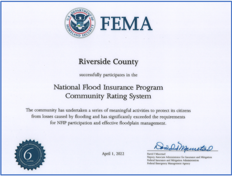
Community Rating System
What is the Community Rating System and how do residents of Riverside County benefit?
Residents who live in FEMA mapped floodplains are required to pay flood insurance depending on the level of risk of flooding present on their property. The Riverside County Flood Control District has been working towards getting a premium rate discount for these residents under the Community Rating System (CRS).
The CRS is part of the National Flood Insurance Program (NFIP). The goals of the NFIP are to provide flood insurance to property owners, to encourage flood loss reduction activities by communities, and to save taxpayers’ money. The NFIP makes federally backed flood insurance available to communities that enact and enforce floodplain regulations. To be covered by a flood insurance policy, a property must be in a community that participates in the NFIP. To participate in the program, a community must adopt and enforce a floodplain management ordinance to regulate development in flood hazard areas. The basic objective of the ordinance is to ensure that such development will not aggravate existing flooding conditions and that new buildings will be protected from flood damage (see Riverside County Ordinance 458 for more details).
Under the CRS there is an incentive for communities to do more than just regulate to the minimum national standards. The CRS has three goals: reducing flood damage, strengthening and supporting the insurance part of the NFIP, and pursuing a comprehensive approach to floodplain management. Communities can participate in “higher standard” activities that reduce flood damage to existing buildings, manage development in areas not mapped by the NFIP, protect new buildings beyond the minimum NFIP protection level, help insurance agents obtain flood data, and help people obtain flood insurance.
The primary benefits of joining the CRS are insurance premium rate reductions to policy holders. Currently, Unincorporated Riverside County residents are eligible for a 20% discount on their flood insurance premiums.
In addition, participating in the CRS Program has multiple secondary benefits. CRS floodplain management activities provide enhanced public safety, a reduction in damage to property and public infrastructure, avoidance of economic disruption and losses, reduction of human suffering, and protection of the environment. Through the CRS a community can evaluate the effectiveness of its flood program against a nationally recognized benchmark. Implementing CRS activities, such as floodplain management planning, can help a community qualify for certain federal assistance programs.
Flood Zone Determination
What is the flood zone designation for my property?
Please provide APN and Address of the property. You can also check yourself using our Public Flood Hazard Determination Interactive Map
The FEMA maps put my property in a flood zone. How do I correct this error?
You file for a LOMA with FEMA. LOMA stands for a Letter of Map Amendment and is issued by FEMA. FEMA would like to have as much evidence as possible before they declare you property is indeed erroneously placed in a flood hazard area.
I am ready to close escrow on property that I intend to subdivide. How do I find out what flood zone it is in and what requirements do I have to fulfil in order to be able to subdivide the property?
This question is twofold. You may look up the flood zone for your property by providing the APN. The response to your second question is complicated and this FAQ can not provide you with all possible scenarios. In general, we determine whether there is a sufficient buildable site on each proposed lot. You will have to protect the proposed lots from offsite storm runoff. Your project shall not concentrate, divert, or obstruct stormwater or adversely impact adjacent properties. Additionally all of the offsite and onsite storm runoff shall be conveyed to an adequate outlet. It is best to consult an engineer who has expertise in the field of land division in the County.
I have a parcel of land where I wanted to build a house. However, County Planning told me that I am in a floodplain and need to contact the Flood Control District. I know I am not in a FEMA designated floodplain. Why do the people at Planning tell me that I am in a floodplain and what do I do about it?
Your property may be in an Ordinance 458 floodplain area. Not all the areas subject to flooding are mapped by FEMA. The District has identified some areas that are severely affected due to the 100-year flood and these have been adopted into Ordinance 458 without having a FEMA flood designation. This may be the reason you are told you are in a floodplain. In many cases, a land division may be approved on a condition that the floodplain on the property be free of buildings, obstruction and landfill. Although this case falls neither under FEMA floodplain nor under an Ordinance 458 floodplain, there may be a portion of the property that is prone to flooding. In this case, although there is adequate building site, a part of the lot is believed to be prone to flooding and this hazard shows up at a time you try to obtain a building permit. It is best if you come to our office and request assistance.
FEMA Documents
What is a LOMR, CLOMR, LOMR-F, CLOMR-F, LOMA etc?
LOMR, LOMR-F and LOMA are all some form of final determination for a revision request. Final revisions to the floodplain limits of a specific area are made through one of these letters. CLOMR, CLOMR-F are all conditional determination for a revision request. A property that has a conditional determination remains in a flood hazard area until a LOMR is requested and issued by FEMA.
Where can I get a copy of a LOMR?
We may have a copy of a LOMR for properties located in the unincorporated parts of the county and for which LOMRs are issued. You can inquire whether a LOMR is available by providing your APN
Where can I get a copy of the Flood Insurance Rate Map for my property?
You may drop by our office and purchase a copy at nominal cost or you may contact FEMA's Map Assistance center @ 1.877.FEMA MAP (1.877.336.2627). You may also be able to get a small size copy of the map from FEMA's website at https://msc.fema.gov/portal and enter the address in the search box. To request a copy of the map from FEMA, by phone or from their website, you must know the community-panel number and suffix of the map.
Can I process a LOMR-F or LOMA? If so what do I need?
At a minimum you must hire a licensed land surveyor or civil engineer. All the necessary information should accompany the request. Additional information in the process and the current fee schedule can be obtained from https://www.fema.gov/letter-map-amendment-letter-map-revision-f-tutorial-series-choose-tutorial.
I am a consulting engineer and looking for a hydraulics and hydrology backup for a certain flooding source. Where can I get that information?
We maintain a library of hydraulic and hydrologic information, it is best if you come to the office and request help.
Where can I get a copy of the FIS report for my community?
f you are interested in the FIS report for the unincorporated parts of Riverside County, we have a copy of the current FIS and you may be able to get a copy at nominal reproduction cost. You may also download it online at https://msc.fema.gov/portal/advanceSearch by entering the Community under Jurisdiction, then selecting FIS Reports from Effective Products.
Where do I get backup for a CLOMR/LOMR?
We may have copies of such backups. Please contact the FPM section for information.
I have a project located in a FEMA floodplain and my conditions of approval require me to obtain a CLOMR prior to grading and a LOMR prior to occupancy. How do I go about fulfilling this requirement?
Call the District's FPM section for information and direction.
A flood control channel is under construction in my area and I wonder if it can help get rid of the 100-year flood zone designation and remove my property from the floodplain.
If your property is in a FEMA mapped floodplain and we are constructing a flood control channel close to your area, chances are the facility will reduce the flooding risk to your property. The District requests a LOMR from FEMA as soon as a flood control facility is completed according to design plans.
Elevation Certificates
What is an Elevation Certificate?
This form is prepared by FEMA to clearly show what the risk of flooding is for a specific structure. It is usually filled out after a structure is completed and it provides 'as-built' information for the structure. A structure with a properly completed Elevation Certificate may qualify for a discount on flood insurance premiums.
Where do I get a copy of the completed Elevation Certificate for my property?
All Elevation Certificates in the District's files can be downloaded and/or printed for your use. Find your Elevation Certificate
What do I do if there is no Elevation Certificate for my property?
It is recommended to download/print a blank copy of the elevation certificate from http://www.fema.gov/media-library/assets/documents/160?id=1383 and have it completed in accordance with the instructions contained in the form. It may be necessary to hire a licensed surveyor at your expense in order to complete the form.
Flood Insurance
How do I go about getting flood insurance?
Contact your homeowners' insurance company. Please note that the flood insurance premium should be the same regardless of which insurance company you contact, so long as the coverage and deductibles are the same.
My property is NOT in a floodplain, but I am worried that I may suffer flood damage if it rains heavily this year. How do I go about acquiring flood insurance for my property?
FEMA has a flood insurance program referred to as Preferred Risk Policy for properties located in low risk areas. Information can be obtained at https://www.fema.gov/pdf/nfip/manual201105/content/09_prp.pdf
Why do I pay flood insurance?
If you own a property and the property is in a FEMA mapped floodplain and you have to borrow money to finance the purchase of the property, flood insurance is mandatory. Please note that the flood insurance covers only the structure(s) and the contents thereof. You may want to check in what flood zone your property is located.
How do I get out of paying flood insurance?
This response assumes you are indeed in a mapped floodplain. The simple answer is by having your property qualify for removal from the floodplain. FEMA is the only agency that has authority to remove a property from a 100-year flood zone designation. Before you invest time and money on this quest contact us and see if there is any LOMR for your property and, if not, ask what is involved in getting a property out of a 100-year flood zone designation. The basic rule is, if you are certain your property is on high ground by means of fill or the natural lay of the land, and if you can prove it to FEMA, you may have a chance of getting the flood designation removed.
My lender says I am in a floodplain and therefore I have to buy flood insurance, and I believe I am not. How do I go about resolving this issue?
You and your lender need to file for a LODR. A LODR is letter of Determination Review. Once FEMA receives all the necessary information, they will issue the LODR. Please note that the LODR may or may not be in your favor.
Flood Permits/Separate Application/Floodplain Management Review
What is a Floodplain Management Review?
If you are proposing to build a structure within a FEMA mapped floodplain or Ordinance 458 floodplain, the proposed structure has to be constructed in such a way that it would not suffer damages due to the 100-year flood. Additionally, the construction of such a structure should be done in such a way that it does not obstruct the free flow of storm water, nor divert or concentrate storm flows.
What do I need to show on a Floodplain Management Review Case?
The plans for a floodplain management review case shall, at a minimum, include lot size, location, topography, proposed finished floor elevation, proposed erosion protection, proposed flow through area, and a typical section of the slab and foundation.
My lot is located in a floodplain, do I need a special permit to build a house on this lot?
Yes, you need to submit plans prepared in accordance with Ordinance 458 and submit your plans with a permit application to your nearest County Building and Safety Department or Planning Department office. Before you prepare plans and apply for a permit, it is best to contact us to find out whether the lot is adequate for the intended project and to get more information regarding any restrictions.
How long will it take to approve my Floodplain Management Review Case?
Ordinance 458 requires us to respond to Floodplain Management Cases within 30 days of receipt of the plans. Approval of the case depends on how well the plans are prepared and how well they fulfill the requirements.
I am processing a Floodplain Management Review and I have conditions of approval for the case. One of the conditions states that I need to turn in a completed Elevation Certificate. Why?
The Elevation Certificate will give us the information whether the building is elevated/floodproofed in accordance with the requirements stated in the condition. It is also a NFIP requirement that we keep such records. We maintain copies of elevation certificates in our files and make copies of the Certificate for future owners of the property.
Do the plans for a Floodplain Management Review have to be prepared by a Civil Engineer?
Yes, in accordance with Ordinance 458, plans submitted for Floodplain Management Review must be prepared and certified by a civil engineer registered in the State of California.
Flood Zone Determination
What is the flood zone designation for my property?
Please provide APN and Address of the property. You can also check yourself using our Public Flood Hazard Determination Interactive Map
The FEMA maps put my property in a flood zone. How do I correct this error?
You file for a LOMA with FEMA. LOMA stands for a Letter of Map Amendment and is issued by FEMA. FEMA would like to have as much evidence as possible before they declare you property is indeed erroneously placed in a flood hazard area.
I am ready to close escrow on property that I intend to subdivide. How do I find out what flood zone it is in and what requirements do I have to fulfil in order to be able to subdivide the property?
This question is twofold. You may look up the flood zone for your property by providing the APN. The response to your second question is complicated and this FAQ can not provide you with all possible scenarios. In general, we determine whether there is a sufficient buildable site on each proposed lot. You will have to protect the proposed lots from offsite storm runoff. Your project shall not concentrate, divert, or obstruct stormwater or adversely impact adjacent properties. Additionally all of the offsite and onsite storm runoff shall be conveyed to an adequate outlet. It is best to consult an engineer who has expertise in the field of land division in the County.
I have a parcel of land where I wanted to build a house. However, County Planning told me that I am in a floodplain and need to contact the Flood Control District. I know I am not in a FEMA designated floodplain. Why do the people at Planning tell me that I am in a floodplain and what do I do about it?
Your property may be in an Ordinance 458 floodplain area. Not all the areas subject to flooding are mapped by FEMA. The District has identified some areas that are severely affected due to the 100-year flood and these have been adopted into Ordinance 458 without having a FEMA flood designation. This may be the reason you are told you are in a floodplain. In many cases, a land division may be approved on a condition that the floodplain on the property be free of buildings, obstruction and landfill. Although this case falls neither under FEMA floodplain nor under an Ordinance 458 floodplain, there may be a portion of the property that is prone to flooding. In this case, although there is adequate building site, a part of the lot is believed to be prone to flooding and this hazard shows up at a time you try to obtain a building permit. It is best if you come to our office and request assistance.